
Surveying Has Never Been Faster or Easier
Delfy is an advanced software package designed to help surveyors and geo-professionals collect, process, and analyze surveying data with precision and efficiency. Built with ease of use and quality as key principles, Delfy is an ideal solution for both small and large projects.
Lightning-Fast Adjustment
Delfy is powered by Geodelta's ultra-fast adjustment engine. This engine is the same one used for the adjustment of extensive photogrammetric networks and MODUPS. The optimizations required to process these large networks efficiently also ensure that surveying networks in Delfy are adjusted at exceptional speed. So fast, in fact, that the first adjustment phase (free network adjustment) runs continuously in the background without you noticing.
Adjustments in Delfy follow the Delft Method for Adjustment and Testing - a methodology used in the Netherlands for processing cadastral measurements, deformation analysis, and recording highly accurate topography. Thanks to its simple user interface, anyone can quickly start using this powerful geodetic data processing method.
In the Field, at the Office, and in the Cloud
Delfy goes with you into the field. With Delfy, you can directly control your Total Station or GNSS receiver—no separate field book is required. Distance measurements from a DISTO are also instantly visible in Delfy without the need for manual input. This means you can see how your network is being built in real time and perform preliminary adjustments and checks in the field before packing up your instruments. Prefer to use your trusted field book? Delfy’s simple import options allow you to bring your field measurements into the software while still in the field.
At the office, you use the same software to perform your network adjustment and build your map. Export results directly to popular CAD and GIS formats, or create a professional plot as a PDF.
Delfy is cloud-native, allowing all data to be stored and shared in the cloud. This ensures that no data is lost, and you can easily continue working on your project back at the office.
When Quality Matters
First introduced in 1992, Delfy was completely redeveloped in 2022 based on Geodelta's ultra-fast adjustment engine, initially built for photogrammetric adjustment and deformation analysis. The guiding principle is that every surveyor should be able to perform their measurements easily and monitor quality effectively. Delfy enables you to conduct all relevant checks in the field, eliminating the need to return to correct failed measurements.
What You Can Do with Delfy
Delfy offers a wide range of convenient features, including:
- Seamless integration with map services: Delfy integrates effortlessly with popular web services such as WMS, WMTS, and OGC APIs, allowing you to easily load and visualize map layers within your projects.
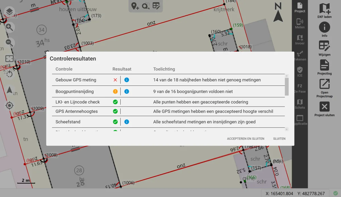
- Comprehensive automatic checks: Delfy performs various automatic checks during the measurement process, such as verifying classification accuracy and GNSS quality, to identify errors immediately.
- Integration with external surveying instruments: Delfy connects directly to instruments such as Total Stations and GNSS devices, enabling real-time recording and analysis of measurements within the software.
- Automatic updates and easy management: Delfy is simple to install and maintain, with automatic updates ensuring that users always have access to the latest features without added management effort.
Want to Learn More?
Interested in simplified data collection and adjustment for your surveying tasks? Contact us to learn more about Delfy.