The March Omnibase update is now available, bringing new features and improvements to existing functions.
First release of the Omnibase documentation website
The new documentation website is available within Omnibase. It provides information about how Omnibase works, its features and the techniques it uses.
The manual explains how to work with Omnibase and describes all the options and measurement tools available in the viewer. It also includes step-by-step instructions for tasks such as uploading and converting data and setting up projects.
This first documentation release may not cover every part of Omnibase. Further information and more detailed explanations will be added in future updates.
Accessing the documentation
Open the documentation using the question mark in the top-right corner of the viewer and select “Open help website”. You can also access it directly at www.omnibase.cloud/help.

Example of the documentation website content
Adding holes to measurements and annotations (polygons)
Omnibase supports viewing, editing and creating polygons with holes. This is useful when openings or internal boundaries need to be modelled.
Procedure:
- First draw or measure a polygon in the measurement or annotation module.
- Right-click the polygon and select Change geometry (“Wijzig geometrie”) to enter editing mode.
- Right-click the polygon and select Add hole to polygon (“Voeg gat toe aan polygoon”).
- Draw the hole and save the measurement or annotation.
Validation:
- Omnibase automatically checks whether the geometry is topologically valid.
- If the hole lies outside the polygon or the geometry is invalid, the measurement or annotation cannot be saved.
- Validation of self-intersecting polygons has also been implemented.

A hole added to geometry in editing mode
Updated dataset menu and virtual datasets (data collections)
Virtual datasets have been introduced in preparation for timeline filtering. They allow several existing datasets to be combined and displayed as a single virtual layer within an Omnibase project.
This is already useful for combining separate datasets, such as several project areas, so the viewer displays one combined layer instead of several separate layers.
Various bug fixes, performance improvements and other updates
Alongside the new features and improvements, various bug fixes, performance improvements and other updates have been implemented:
- Faster loading of 3D Tiles, with a choice of loading quality: low, medium or high.
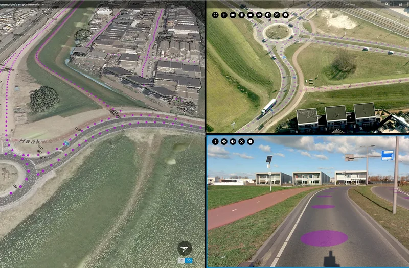
- All panoramic image locations are now shown within an open aerial photograph.
- Validation of self-intersecting polygons.
- The dataset coverage highlight (the purple area) appears only after the mouse pointer has hovered over the layer for at least one second.
- An annotation loading bar is shown at the bottom of the screen, indicating how many annotations have been loaded when opening a project.
- Selected elements, such as an annotation, are highlighted in all views.
- The cross-section option has also been added to the annotation measurement menu.

Split screen: point cloud (left), aerial photograph (top right) and panoramic image (bottom right)
Developments for upcoming releases
Geodelta continuously improves Omnibase’s performance and extends its functionality. The developments below include improvements to existing features and new capabilities that will become available soon.
We are currently working on:
- Adjusting panoramic image colours: a dataset setting for displaying, for example, panoramic images from several different years.
- Linking the panorama view to the 3D view: linking split-screen panoramic images to a 3D view so that the 3D view follows when the panoramic image is panned.
- COPC support: full support for Cloud Optimized Point Clouds (COPC).
- Time filter: filtering data from different dates using a time slider, for example to select photographs by year.
- Connector: a generic connection method that allows external software to connect to Omnibase.
Would you like to learn more about Omnibase’s other features? Please contact us.